


With Ruil Alabi and Emman Magpusao reporting from Brooke’s Point. Satellite data and GIS analysis by Alvin Natividad
(Part 1 or 2 parts)
From a distance, the Saraza ridge in Brooke’s Point, southern Palawan, looks like something scraped clean. Flying a drone over the range, the first thing that registers is the scale of it. It is not just a clearing here and there, but an entire hillside of the Mt. Mantalingahan as far as the eye can see worn down to reddish-brown soil, punctuated by thin lines of grass and a few skeletal trees that did not make it to the burn.

Below the bare ridge, a mosaic of green in different stages of recovery shows clearings being reclaimed by scrub, the newer ones still raw. At the edges are what used to be closed-canopy forest still holding a faint dark line against the sky.
This is kaingin. Slash-and-burn agriculture, practiced inside a protected landscape and a candidate UNESCO World Heritage Site. The entire Mantalingahan range that this area is part of, according to Conservation International Philippines, has lost more than 20 percent of its upland and mangrove forests to illegal forest clearing in the last two decades.
A satellite image analysis of Saraza commissioned for this story using the latest available datasets shows the upland terrain as a field of dark green forest punctuated by dozens of red-classified patches, each one a kaingin plot identified by spectral analysis. Taken together, these kaingin plots cover 286.57 hectares of Saraza’s highest elevation.

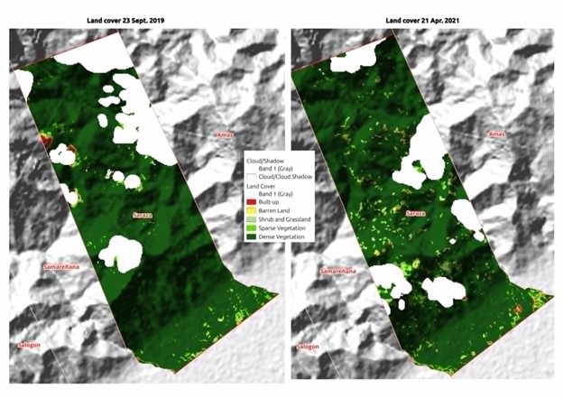
Saraza on the ground zero of kaingin
Bendina Awang, a Palaw’an mother, lives off the land with her kaingin patch as her sole source of livelihood. She vows that her plot is only one hectare where she harvests rice, root crops and whatever the burned soil will yield in a single season.
“Kinakain lang namin po. Sa konsumo lang talaga. Kasi kung ibenta pa yan, wala na kaming makakain.” (We eat it ourselves. It is purely for consumption. Because if we sold it, we would have nothing to eat.) “Kung hindi kami magkaingin, mamatay na kami. Yan ang hanapbuhay namin.” (If we do not do kaingin, we will die. That is our livelihood.)
When asked whether government aid reaches Saraza, she pauses. “Kung mayroon man, parang pili na lang din. Ano na lang, may palakasan na lang.” (If there is any, it seems like it only reaches those who are chosen. There is favoritism.)

While PCSD’s Jovic Fabello pointed out that large-scale kaingin across southern Palawan is driven primarily by non-IP farmers and in-migrants from lowland areas who do not practice traditional rotation, this isn’t the case in Saraza at all.
Saraza Barangay Captain Erlito Paalan told Palawan News in an interview that he is certain there are no non-indigenous farmers in the area. “Wala pong mga hindi katutubo ang mga nagkakainin. Kasi ayaw rin nila mapasokan yan ng mga ibang lahi. Puro mga katutubo po iyan,” he said. (There are no non-indigenous people doing kaingin here. Because they themselves do not want other ethnic groups entering their territory.)

Paalan pointed out that the community’s tribal chieftain has been advising farmers to stay within their traditional plot areas and not expand. “Yung iba, hindi mo rin mapigilan nga. May gusto rin magdagdag pa,” he said. (Some of them, you really cannot stop. They want to add more area.) “Sa hirap nga rin po ng buhay ngayon, wala rin silang ibang alternative na mapagkakitaan. Talagang nag-additional sila ng area,” he added. (Of course, given how hard life is now, they have no other source of income. They really are expanding into additional areas.)
Increased flooding
Below the cleared ridges of Saraza, the Macagua River runs brown when it rains.
“Bumabaha po talaga dito kung tag-ulan po, sir. Minsan po, lumilipat kami sa school,” Farah Luana, who lives near the riverbank. (It truly floods here during the rainy season. Sometimes we evacuate to the school.)
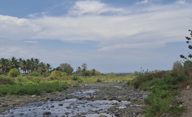
Benencia Batuan, another local resident, thinks the flooding is not connected to the denudation above but because the monsoon are just heavy. “Sa sobrang ulan lang siguro kasi malayo naman yung mga kaingin.” (I don’t think so. It’s probably just the heavy rain. Because the kaingin is far away.)
Kap. Paalan is bold to admit what community members are reluctant to draw. “Dati-dati hindi pa nage-spread yung pagkakainin, hindi pa naman din malakas masyado ang pagbaha,” he said. (Before, when the kaingin had not yet spread this much, the flooding was not this severe.) “Isa sa mga cause na po yun.” (It is one of the causes.)
He went further, stating that during his survey of the barangay’s upland terrain, he saw the trend of expansion.
“Sabi ko nga kung ito ay matuloy pa at maglalapad pa ng gusto, magdudulot ito talaga ng malakas na pagbaha. Kawawa po yung mga nasa baba.” (If this continues and keeps spreading, this will surely cause severe flooding. The people below will suffer.) “Konting ulan lang, diyan na yung baha.” (Just a little rain and the flood is already there.)
The wider landscape
A USAID-funded study in 2025 showed that between 2013 and 2023, Mantalingahan Range lost 19,208 hectares of forest equivalent to 15.89 percent of its total area in a single decade. The study, entitled Sustainable Interventions for Biodiversity, Oceans, and Landscapes (SIBOL), showed that closed forest dropped from 77,705 to 70,534 hectares while open forest shrank from 10,928 to 6,903 hectares. Meanwhile, grassland expanded from 1,380 to 8,660 hectares, and barren land from 325 to 2,111 hectares.
The data, by far the most alarming dataset yet produced for MMPL, suggests that kaingin plots are being abandoned before the forest could even recover.
A separate but consistent data layer comes from the Hansen Global Forest Change dataset, cited in the SIBOL study, which recorded forest loss of 12,567 hectares across MMPL between 2015 and 2021 alone — nearly 13 percent of what was then 97,887 hectares of forest cover, lost in six years. Conservation International Philippines, citing its own monitoring of the landscape, has stated that MMPL has lost more than 20 percent of its upland and mangrove forests to illegal forest clearing in the last two decades.
The SIBOL study also projected what continued clearing at measured rates would produce by 2028, under what it called a “business as usual” scenario. Across the four southern Palawan municipalities within MMPL for which it produced municipal-level projections, the combined kaingin extent of 489.58 hectares as of 2023 was projected to reach 2,135.84 hectares within five years. That is a projected increase of more than 330 percent. In Rizal municipality, the projected jump was from 187.54 to 818.14 hectares. In Quezon, from 169.79 to 740.71. In Bataraza, from 43.86 to 191.40. In Sofronio Española, from 88.39 to 385.59.
Those projections were modeled using data through 2023. The Saraza satellite map produced for this story is dated April 21, 2026. Whatever trajectory SIBOL was tracking, Saraza’s 286.57 hectares suggests it has not reversed.
Barangay Saraza is just one barangay in one municipality in one protected landscape. The Mt. Mantalingahan Protected Landscape spans five municipalities and 120,457 hectares. If Saraza’s 286.57 hectares is in any sense representative of conditions across the landscape — and the SIBOL study’s data on the broader MMPL suggests it may understate the picture in some areas — then the aggregate kaingin footprint across the protected area is an order of magnitude larger than any comprehensive study has made.
A question of sustainability
The Saraza imagery did not distinguish which burnings were traditional farming practices of the indigenous communities and which were not. Under Republic Act 8371, the Indigenous Peoples’ Rights Act of 1997, indigenous cultural communities hold the right to maintain and develop their cultures, traditions, and institutions, including their systems of land use and resource management within their ancestral domains. The IPRA does not carve out an exception for protected areas. It recognizes that for many indigenous communities, the forest and the farm are not opposites but are part of the same managed landscape, cycled through in patterns that sustained both the people and the trees for generations before any proclamation gave the mountain a legal name.
That fallow is what makes traditional kaingin sustainable. However, currently available data is challenging that long-held notion and suggesting instead that fallow is collapsing. The question being posed by the data is whether kaingin as it is currently practiced across the slopes of Mantalingahan still resembles the traditional rotation the IPRA was designed to protect, or whether it has been transformed, by pressure and circumstance, into something ecologically different.
While there are no explicit studies made on practice of kaingin in the province, the Palawan Council for Sustainable Development (PCSD) believes that non-IP farmers are the ones mainly responsible.
“Kung may IP na magkaingin ng ganyan, siguro pa ilan-ilan. But non-IPs na karamihan ang gumagawa niyan,” Jovic Fabello, PCSD spokesperson, told Palawan News.
The Environmental Legal Assistance Center, an NGO based in Puerto Princesa, argued that framing kaingin as the primary cause of deforestation without addressing its structural drivers amounts to “scapegoating”. In a statement responding to the PCSD’s position, ELAC said that ‘weak enforcement, inadequate resource allocation, and the exclusion of affected communities from decision-making processes’ are the real issues and that attributing forest loss primarily to small upland farmers diverts attention from the real issues.
The disagreement about causes and culpability has not stopped the clearing. Whatever the correct assignment of institutional responsibility, the forest loss is measurable, dated, and growing.
An expert’s caution
Wolfram Dressler, an Associate Professor at the University of Melbourne whose work on Palawan’s swidden farming and indigenous land use spans more than two decades, raised concern on how the kaingin problem is currently framed.
“IP kaingin has been vilified for centuries. IP farmers have long faced penalties, imprisonment, and dispossession as a result. Pushed into the mountains, they have lived within and worked forests for kaingin across generations. It is a living tradition in the Philippines and deserves support, not condemnation,” he told Palawan News.
Dressler argued that IP kaingin is generally more sustainable than migrant settler kaingin. “Most plots are small, typically 0.25 to 1 hectare, and when in long fallow of more than five years, fields regenerate into forest to produce diverse landscape mosaics. Dynamic firebreaks are used to manage burning, and firing is carried out carefully, away from older forests,” he said.
He adds that “much of the deforestation in the hills leading to the Mantalingahan Range stems from coercive land grabs and from IPs being compelled to sell land under political pressure and economic necessity.”
Where the ground evidence from Saraza complicates Dressler’s framework is the flooding. Paalan’s testimony that a little rain is now enough to bring a flood suggests the cumulative removal of slope cover has already crossed a watershed threshold, regardless of how carefully individual plots were fired.
Whether IP kaingin is sustainable in the abstract is a separate question from whether the clearing in Saraza is compatible with the watershed function the communities downstream depend on to survive.
(Next: A similar data analysis on the forests of Rizal and Puerto Princesa City)


